In completing this course you will receive the Metro Severe Thunderstorm Warning qualification.
You will be enrolled in this course by your assessor once your assessment date has been set.
- Teacher: Ross Bunn
- Teacher: James Pescott
- Teacher: Peter Stapleton
This course contains the supplementary assessment materials requires to obtain the Regional Severe Thunderstorm Warning qualification.
There is still an in person assessment to be completed alongside the content of this course to be able to achieve completion of the course.
In completing this course you will receive the Regional Severe Thunderstorm Warning qualification.
You will be enrolled in this course by your assessor once your assessment date has been set.
- Teacher: Ross Bunn
- Teacher: James Pescott
- Teacher: Peter Stapleton

Training material that highlights common synoptic patterns and environments for thunderstorms and severe weather across Australia. It covers how operational meteorologists can diagnosed systems and associated synoptic features along with their atmospheric conditions. In addition, it delves into radar interrogation and signatures as well as operational procedures for escalating situations.
- Teacher: Karl Brunckhorst
- Teacher: Andrew Bufalino
- Teacher: Ross Bunn
- Teacher: James Pescott
- Teacher: Peter Stapleton
Overview
This training module has been developed to provide training and guidance on the convective analysis process for forecasters all across Australia. The module provides instructional materials, including demonstration videos, on the process of performing a convective analysis and the key fields and convective parameters by which to do this. It also includes practice exercises to test your knowledge gained on the 4 main topics. The overall learning section of the course, inclusive of all instructional material and time to complete exercises, holds approximately 5 hours of content, though no one piece of instructional material is any longer than 20 minutes.
It aligns with the Severe Thunderstorm competency performance criteria covering convective analysis so forecasters are trained in accordance with the skills required for producing a convective outlook and can obtain the Thunderstorm Forecasting qualification. The assessment required to be completed to obtain the qualification involves completing two quizzes which takes a total of 3.5 hours to complete.
The course has been developed in partnership with the Extreme Weather Desk to ensure a nationally consistent and best practice approach.
Learning Outcomes
This course covers the following broad learning outcomes linked to each section:
- Complete an analysis of the current convective environment
- Complete a Basic Thunderstorm Assessment
- Complete a Thunderstorm Mode Assessment
- Complete a Severe Phenomena Assessment
These are then broken down into mores detailed outcomes in each section.
Course Outcome
To complete the course you must complete the assessment which involves completing two quizzes and the outcome of this is gaining the Thunderstorm Forecasting qualification.
Assumed Knowledge
It is assumed that you have knowledge of the Thunderstorms subject from the graduate meteorologist course as this course does not delve into the theory of thunderstorms, but focuses on the application of the theory to forecasting. It is also assumes you have familiarity with operational systems and products in the thunderstorms area.
- Teacher: Ross Bunn
- Teacher: James Pescott
- Teacher: Peter Stapleton
- Teacher: Ross Bunn
- Teacher: James Pescott
- Teacher: Dean Sgarbossa
The WDSS hail diagnostics from radar reflectivity have been upgraded to gridded hail products called MESH, MESH Swath and POSH. These gridded products can be used to better identify severe hail-producing storms, track trends in intensity and estimate hail size. This course covers the strengths and limitations of MESH, MESH Swath and POSH.
Method: Online Duration: 1.25 hours Assessment: One short quiz requiring 80% to pass Help: Contact Ross Bunn (03 9669 4264) | 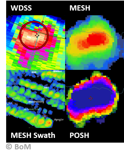 |
|---|
- Teacher: Ross Bunn
- Teacher: James Pescott
- Teacher: Peter Stapleton
A particle identification product (ParticleID) uses dual-pol data to classify hydrometeors into types (rain, hail, rain-hail mix, snow and graupel), and can be used as a heads-up to the presence of hail. This module will cover the construction of the ParticleID product, and demonstrate how ParticleID can be used to nowcast hail. Method: Online Duration: 1 hour Assessment: One short quiz requiring 80% to pass Help: Contact Ross Bunn (03 9669 4264) | 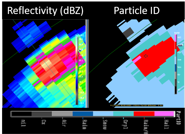 |
|---|
- Teacher: Ross Bunn
- Teacher: James Pescott
- Teacher: Peter Stapleton
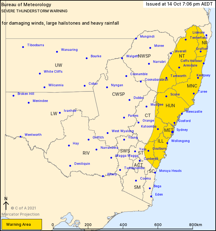
This is an introductory course into the warning software TIFS which is used to produce severe thunderstorm and severe weather warnings.
There are 5 demonstration videos that cover the TIFS interface and layout, how to issue a state severe thunderstorm warning, how to issue a cell based severe thunderstorm warning, how to issue a severe weather warning and how to cancel all of these warnings.
Note: The original videos are based on version 9 of TIFS (released 2016) but there is now an update page about the most recent release, version 11, which includes the short demo video, which should bring you up to speed with some of the latest and crucial changes.
These videos are only introductory so the establishment and improvement in skill with TIFS will require working through case studies or more on the job practice.
| Help: | Contact Peter Stapleton |
- Teacher: Ross Bunn
- Teacher: James Pescott
- Teacher: Peter Stapleton
- Teacher: Ross Bunn
- Teacher: James Pescott
- Teacher: Peter Stapleton
Welcome to the new and improved cool season severe thunderstorm (STS) training module.
The module has been updated to include a quiz and a link to EBS accreditation for completing the training via completing the quiz.
So why are we studying this area and looking to improve our understanding of cool season STS.
- There is a significant difference between warm and cool season STS so it is important that you understand how cool season STS work and how to approach it from a forecasting point of view as it is different to the warm season approach and understanding.
- Cool season STS have a significant impact on southern Australia, and for WA and SA it is an equal or greater impact than warm season, so it is important that we understand them to provide a good forecast and warning service to the public.
- By learning more about cool season STS and applying that knowledge to forecasting and warning approaches then there will be an improvement in cool season forecasting.
The module is broken up in to four parts and these parts are delineated by a colour coding which will be seen as we introduce the sections.
Theory: The first part is the theory section, which has a green heading colour. This section will cover what environmental conditions create a cool season STS, how a cool season STS is different from warm and the mechanisms which produce the severe phenomena.
Real-world: The second part is the real-world section, which has a red heading colour. In this section we will look at the climatology of cool season STS in southern Australia and look at the impact of past cool season STS events. These two things will demonstrate the threat cool season has to significant population area of southern Australia.
Operations: The final section is the operations, which has a blue heading colour. It will bring together what we have learned from the first two sections and see how we can apply them as forecasting ideas and techniques to improve our cool season STS forecasting. Also we will look at how different RFCs manage their warning strategy for cool season and how this can be applied as a best practice approach.
Exercises: The final part of the module contains exercises in the form of a quiz. The quiz should take 10-20 minutes to complete and is required to be completed to gain EBS accreditation.
| Method: |
Blended |
| Duration: | Usually 2-3 hours for the module, 10-20 minutes for the quiz. All tasks could be completed in a half day off shift. |
| Assessment: |
By completing the quiz you will complete the course and gain accreditation on EBS for going through the training. |
| Help: |
Contact Peter Stapleton Email: peter.stapleton@bom.gov.au Phone: 0396694332 |
- Teacher: Ross Bunn
- Teacher: James Pescott
- Teacher: Peter Stapleton